Day 2: Monday, June 16, 2003
I set out shortly after 8 AM heading east again on I-80 from Elko, Nevada. I decided to ride for about two hours, then stop for breakfast.
A few miles east of Elko the scenery changed. In this part of eastern Nevada, I actually began to see trees. Trees are rare in most of Nevada. However, my excitement was short lived. A few miles later the trees disappeared and it was back to sand and sagebrush.
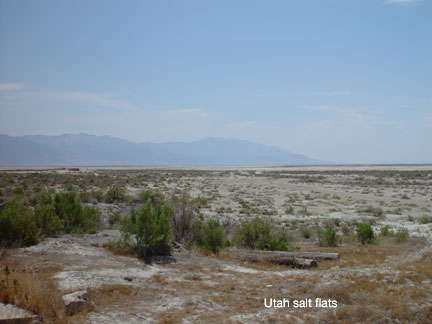
I decided West Wendover, on the Utah line, would be a good place for breakfast. The approach to West Wendover on Interstate 80 is very dramatic. The highway crests a pass, and suddenly all the mountains disappear and there is nothing ahead but white salt flat as far as the eye can see. Bonneville, Utah, where the land speed records are set on the salt flats, is just a couple of miles past Wendover across the Utah line.
West Wendover proved to be a bust for breakfast. I hadn't realized there was an hour time change from Elko. Apparently West Wendover uses Utah time (Mountain Time Zone) because it is right on the Utah line. So I stopped at McDonald's thinking it was 10:10 AM and I could get my favorite sausage biscuit with egg breakfast, but was quickly informed that it was 11:10 AM and McDonald's had stopped serving breakfast. However, they told me, breakfast was served in the casinos until 1 PM. I cruised the town and discovered an incredible mecca of construction for elaborate new casino hotels -- apparently an escape from the straight-laced rules of Utah. Not being a fan of casinos, I rode on to the salt flats. I figured I could always snack on one of my granola bars along the way, and I had targeted the Borders Books and Music cafe in Salt Lake City for coffee and email connection via T-Mobile.
About 10 miles past Bonneville I remembered my other reason for stopping at West Wendover: to get gasoline! I was down to less than a quarter tank, and there were 110 miles of desolation and salt flats between me and Salt Lake City.
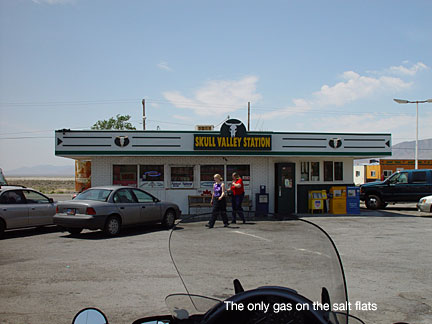
I hooked my hope on a road sign announcing the town of Knolls only 30 miles ahead. I knew I could make that. On reaching Knolls, however, there were "no services." I adjusted my speed downward to 60 miles per hour to save fuel and hoped for a miracle. The next three or four exits also had "no services." Finally I found a service station at Skull Valley and tanked up about 50 miles short of Salt Lake City. I might have made it. My reserve fuel light came on just as I pulled into the station, and that is supposed to mean I have a little more than one gallon of fuel left. On the BMW, that should get me up to 55 miles at conservative speed. But I have never actually tested it. I was also thinking there might be some suburban gasoline stations west of Salt Lake City, but I would have been disappointed in that hope. The desolation of this part of western Utah extends completely up to the Great Salt Lake and right into the northern portion of the city itself. No services. Skull Valley Station is the only gas station in 120 miles from Bonneville to Salt Lake City.
Temperatures were a little cooler today than on Sunday. The bike thermometer never registered more than 85 degrees coming across the salt flats. Salt Lake City itself was the hottest spot, touching 90.
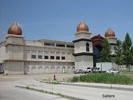
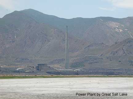
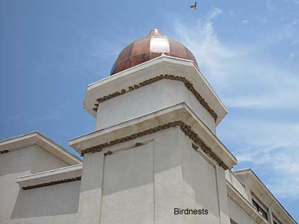
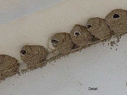
On the approach to Salt Lake City, Interstate 80 passes along the south shore of the Great Salt Lake. On the lakeshore I saw ahead a very strange building and got off the freeway at an exit labeled "Saltaire" to see what this was. It turned out to be a very run-down place with only a few cars in the parking lot, which was partially overgrown with weeds and grass. I stopped to look at the lake. There is a beach, but almost nobody was there. There was an annoying stench in the air, from the lake I presume. Opposite, on the south side of I-80, I saw what appeared to be a large power plant. As I stood there, the plant continually emited loud explosive booming noises. Interestingly, some variety of bird has made a home of the eaves of the Saltaire building itself, with nests that hang from the wall of the building in the shade of the roof and appear to be constructed of mud.
I did not enter the Saltaire building, but my guess was that it is some sort of attempt at an upscale shopping area that had failed -- not surprising in view of the smell and the noise. Since then, I have found a bit of information on the internet. Saltaire was apparently a beach resort with a large pavillion with a similar turreted design that was popular with Salt Lake City residents earlier in the 20th century. There was a beach, a pier, a roller coaster, and the pavillion contained parhaps the largest dance hall in North America. At some point, however, Saltaire became unpopular. The pavillion was abandoned and later burned. The present structure was apparently built in the 1980s with an architectural style mimicking the design of the original Saltaire Pavillion, and intended to be a shopping and entertainment center. The place never caught on, however, and has fallen into its current state of disrepair, although it may still be used on occasion as a concert venue.
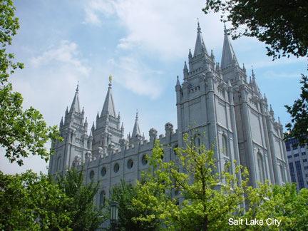
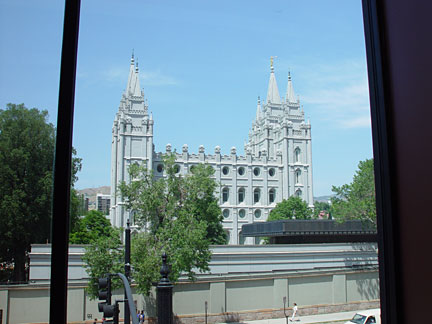
In Salt Lake City, I parked my bike across from Temple Square and walked around taking pictures and listening to the loudspeakers playing songs by the Mormon Tabenacle Choir. Then I went to Borders Books for coffee. The Borders store in SLC is directly across from the Mormon Temple. In fact, the classic postcard view of the Temple can be had directly out the windows of the cafe on Borders' second level. I spent more than an hour fussing with photos and email while having my coffee and pastry. Unsuccessfully, as it turned out. The T-Mobile connection was very slow, and there was also a problem with the email program that prevented me from sending to the mailing list I had compiled for the trip. I decided to move on, try to solve the problem that evening, and send the mail next day from somewhere in Colorado.
I got lost briefly while trying to leave Salt Lake City. For some reason, whenever I'm in SLC I get confused about north and south. It just seems to me that the city should logically be pointed in the other direction. Although Park City and the Wasatch Mountains are east, my brain insists on thinking they are west, with the consequence that I did a big circle around town before finding myself on I-80 headed east. Then, as I climbed up into the mountains I saw dark skies and lightning bolts ahead. I stopped to put on the missing portions of my rain gear -- Aerostich nylon overpants, which I had washed and carefully Scotch-guarded before leaving, as I had also done for my Aerostich jacket. I put on the nylon gaiters I had purchased and treated to protect my socks from conducting water into my boots, as they had in a driving rainstorm when I rode through the Wolf Creek Pass in southwestern Colorado in 1996. Getting the gaiters on was not easy. The successful technique involves removing one's boots, mounting the gaiters on the boots in a scrunched down position, putting the boots back on the feet and lacing them, then pulling the gaiters up over the pants. Not the easiest thing to do when you're standing by the side of the road. Finally, I got my waterproof two-finger nylon overgloves out of the top pack and put them in my jacket pocket, ready to slip over my leather gloves if the rain should come.
Thus equipped, I began riding into the storm. Of course, by this time the storm had moved away, and the rest of my ride this day was dry. But I was ready!
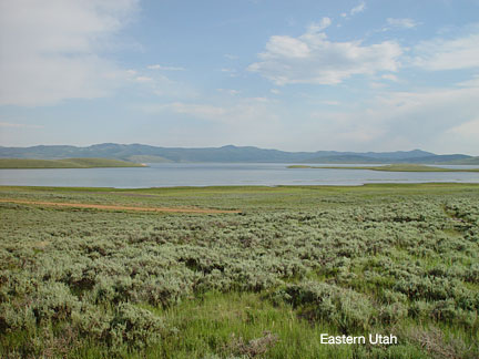
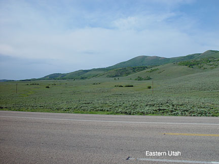
I left I-80 at the US 40 junction and headed east on 40 toward Vernal. This part of eastern Utah is very green with lush grass and trees, although the greenness begins to subside a bit in the last few miles before Vernal. I landed in Vernal just after 8 PM Mountain Time, and Vernal is where I stopped this night, having given up my hope of getting closer to Denver on Day 2.
Vernal, despite the nice sound of it, is actually a relatively nondescript town with a few motels and restaurants and a bunch of statues and stuff about dinosaurs. What's up with that dinosaur stuff in Vernal, Utah?
I walked a couple of blocks from my Econo-Lodge motel to a steak house for dinner. There were pretty waitresses at the steak house -- but they are everywhere in Utah. Walking back to the motel, I was particularly impressed by the Veterans Memorial which I had noticed on my first pass through town because of the old decorated military attack helicopter mounted on top of a tall pole-like pedestal. Now, walking, I noticed the memorial lists on stone tablets, one for each war, and each wrapped in a large yellow ribbon. Vernal must be a very patriotic town.
Now, as usual, I'm up too late writing and fussing with things, so it probably won't be as early a start as I would like on Day 3. I must call Elyse and Boris in the morning and tell them it will take me one day more than planned to get to Minneapolis.